There are different risk-factors that come with different life-callings:
- Fish for King Crab in the Barents Sea: get rich fast, but there is an unusually high risk of becoming crab food yourself.
- Transport cocaine from Colombia to Texas: get rich fast, but there is an unusually high risk of being beheaded.
- Fight forest fires: there is an unusually high risk of joining the Bar-B-Que and burning with the trees. Health insurance wasn’t even introduced until last year. I worked my way through undergrad school fighting forest fires and nearly died several times.
- Work as an accountant: Live Long and Prosper!
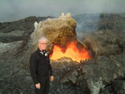
There have been several questions directed at us in Ask-a-Geologist about safety while working as a geologist or geophysicist. These increased, as expected, during the 2004-2006 eruption of Mount St Helens. To a previous question, I mentioned walking out the leading edges of moving lava flows in Hawai’i. This was not done casually, but to gain a clearer understanding of how these flows move – and why they suddenly can inundate towns like Kalapana. If we understand in a statistically reliable way how lava creates its own new topography, perhaps we can predict where the Danger Zones are.
This has non-trivial real-world consequences: if you build in Zone 1 or Zone 2 on the Big Island of Hawai’i, your home-owner’s insurance will be phenomenally high – if you can get it at all.
In a larger sense, however, this opens the broader issue of inherent risk that comes with certain jobs – and how you can manage those risks.
In 1977 a young USGS geologist named Cynthia Dusel was part of a mapping team, surveying the Big Delta Quadrangle in east-central Alaska, when she was attacked and mauled by a bear. She survived, but lost both arms. Since then she has married, had a son, and even served as acting chief of the Western Mineral Resources team in Menlo Park, CA for a year. She’s something of an icon among us in the USGS: very matter-of-fact about her disability, very upbeat, great sense of humor – and she epitomizes indomitable courage (https://gizmodo.com/bear-maulings-and-helicopter-crashes-make-the-need-for-1711777194).
The response to that bear attack within the USGS was probably predictable: everyone going up to work in Alaska started packing huge guns. Then the scientist part in the Survey scientists woke up and many of us thought about it a bit more. Let’s gather data about the real threats to geologists working in Alaska! they said. They did… and were surprised to learn that bear attacks came in as Number 7 on the list. Shooting yourself with your own darn weapon came in Number 3 – I once watched a rattled tech shove a cocked .357 Magnum into his holster. This led to the development of a sophisticated 3-day weapons safety training course (informally called the “Bear Blasting” class, of course) required of anyone planning to work in Alaska. The Number 2 killer of geologists working in Alaska was helicopter accidents – my first USGS boss, a truly great man named Frank Frischknecht, was killed in Ketchikan harbor this way. And this led to careful “carding” (certification) of pilots and aircraft, and mandatory aircraft training of all of us geoscientists. None of us ever worked with a pilot with less than 5,000 hours of flight experience after that, and we always wore NOMEX clothing and $1,500 fighter-pilot helmets, among other things.
The Number 1 killer of geologists in Alaska turned out to be drowning. That’s right: drowning. If you fall into deep water in Alaska (and southeast Alaska and the Aleutians are mostly islands, anyway), your arms will essentially stop working after about a minute unless you are wearing a Mustang suit. That’s hypothermia for you. I came within a hairs-breadth of becoming one of those drowning statistics in Klawock in August of 1995.
It became a growing part of our evolving scientific tradition: we all love working in the field, but it carries with it different dangers. Soooo… how can we minimize these? How can we manage these risks?
Q:
That’s a pretty crazy account. It’s particularly funny to think about your work when I think of it in comparison to our OHS (occupational health and safety) officers who come around to inspect our offices periodically to make sure that our chairs are properly aligned to make sure that we don’t hurt our backs by sitting all day long. Why in the world would you be stomping around an area of jungle amidst fresh-flowing lava? – Lisa W.
A:
Throughout my professional career I’ve faced many rather disparate dangers. This wasn’t done for the adrenaline thrill – it’s the only way in most cases to acquire the crucial data that we need to solve real world problems. In the Continental US, this usually means working in really rugged terrain. I camped overnight with a geophysical crew inside the crater of Mount St Helens in 2007. I had helicoptered in with some geophysical equipment, but after several days had to get back to the office before the end-of-week scheduled helicopter flight. A case in point: I planned for it, and walked out. However, it proved to be far more rugged terrain than I had anticipated in my planning (which was done with 10-yr-old air-photos of a terrain that is still unconsolidated, and evolving with wind and water nearly every day). If I had not been carrying (and using) hiking poles with my pack, I wouldn’t be wearing my front teeth today. I still sustained permanent damage to my left big toe and my right knee in the ~25 km walk-out (the knee is still swollen as I write this – my lateral meniscus was destroyed).
In Venezuela, my personal journals have WAY too many “I was nearly killed again today” entries. That was the first time I really looked at the full array of danger that comes with working in the deep jungle. Initially we went down for a three-year assignment to map the roadless, jungle-covered southern half of Venezuela thinking the the big risk was from snakes. In fact, I encountered a Bushmaster on my very first Entrada. It took awhile to recognize the more subtle, even hidden dangers however: testosterone-poisoned pilots, poorly-maintained helicopters, Chagas disease, piranha in all the rivers, etc. The Number 1 killer? The Anopheles mosquito – the vector for Plasmodium Falciparum, also known as cerebral malaria, followed closely by drunk drivers as the Number 2 killer. I lost two of my best friends in Venezuela, in separate incidents, to drunk drivers.
After a series of very close calls I took the Advanced Trauma Life Support training at the University of Maryland medical school. Yes, it’s supposed to be for medical doctors – but I have the certificate to prove that I passed the course successfully. I discussed the jungle danger issues with some of the more experienced field geologists, and began instituting some safety protocols for the mapping mission that I was in charge of. For starts, we almost never used helicopters after the first year there. I calculated that I could walk, I could even swim in croc-and-piranha-infested waters, but I could not land by myself. We wore light-colored clothes to minimize being targeted by Africanized bees, which nearly got me three separate times. We always walked the picas (trails) in pairs. We always insisted on mosquito nets surrounding our hammocks, etc. I would never permit one of our camps to be within a kilometer of a miners’ camp (the Anopheles mosquito only travels a few hundred meters in its short life). One of my colleagues instituted one safety protocol himself: he just bailed out, breaking his contract and leaving his commitments on my shoulders. I’ve never begrudged him for this by the way: he was one really, really scared dude, and his wife really wanted a Dad to help raise their boys. A year later he even left the Geosciences profession, abandoning all his PhD training, to become a financial adviser.
Live long and prosper.
But here’s the thing: you CAN control the variables, you CAN push the statistical envelope far over to the likely-to-survive side of the Gaussian probability curve.
I took some training last year that is a case in point. You can’t study a volcano unless you can get a lot of equipment up INTO it. My sons and I will attest that just carrying 300 kilos of gear up into the Pumice Plain (the Mount St Helens Blast Zone) for their mom’s Masters Degree biology research project was a non-trivial exercise. It’s much harder to do this in the upper edifice of the volcano – so we (sigh) use helicopters.
Easy to say, technically hard to do.
The safest way to ensure the survival of the helicopter and pilot is NOT to have a lot of loose shovels, antennas, and batteries INSIDE the ship. This little nugget of wisdom was culled by carefully gathering reports of all helicopter crashes in the United States over 50 years. Instead, you *sling* all that loose, sharp-edged junk. There is an electrically-controlled hook on the belly of most helicopters. We took a full day to practice this routine on a level lawn:
- Gather all your gear in a pile, weigh it piece by piece. Give that manifest to the pilot – who will do a calculation to see if he can even lift it to the elevations you will work at – AND have enough margin to carry you along with it.
- Load it into a net that itself weighs 25 kg (55 lbs). Try to balance that net, arrange it so things tilt inward, and especially be sure that nothing is sticking out of the net that could tangle with anything – like you, or the helicopter’s skids.
- Then call the helicopter in to you, holding your hands up and out in the direction of the wind (we usually dangle a strip of red flagging tape from one hand so the pilot can judge the local wind velocity).
- As the ship approaches, it comes in slowly at about 1.5 meters off the ground – remember that the thing is wobbling around in the wind as the pilot tries to control it against the volcano-heat-triggered turbulence, and it is SCREAMING SO LOUDLY that you can easily get rattled just by the 140-db sound (we wear helmets with ear protection, but it’s still very unnerving).
- You must then walk under this shuddering, screaming thing, hook your sling net to the belly, and then carefully back out (NOT turn around), without tangling your feet in the net, and keeping your footing amid the rocks and talus.
- Above all, if you stumble, you must NOT grab one of the skids to regain your balance. If you do, the ultra-light craft will flip, the blades will hit the ground, and all that angular momentum must go somewhere really, really fast – and you will both probably die as the blades tear everything to pieces around you. You have to trust the pilot, and he must trust you: if you hook the net wrong, or inadvertently tangle it in one of his skids, it could kill him. The craft is so fragile that you can literally push it around in the air above you with your hand… but those screaming turbines mean it is powered by 600 very loud horses. Everything spinning is so finely balanced that if a blade nicks a branch it will chip a chunk off – and it then becomes hugely unbalanced. Then the angular momentum comes into play, and the aircraft will literally beat itself (and its occupants, and everyone within 20 meters) to death.
When a helicopter goes down, that’s just the beginning of the bad stuff… think of the old high-school joke: What’s red and green and goes round and round real fast? Answer: A frog in a blender. Now imagine doing this sling exercise on a steep ridge with 30-knot wind gusts. THAT’s why we practice and practice all day long on a lawn to do this right. So it’s reflex. So when the brain starts mis-firing, you STILL do the right things.
This is basically how I teach Jujitsu to my students, by the way. No one ever defended themselves from their Worst Nightmare by using their cerebral cortex – self defense only works from muscle memory: reflex.
Live Long and Prosper. And still enjoy the Adventure!
~~~~~